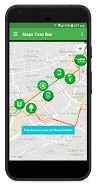
Tool for locations boarding and alighting from public transport units Pachuca (Tuzo Bus) and food stations and routes that have this mass transit system.
? ? ? ?
?Consumo low battery, because when you open a map only looking after your location and off the GPS
?Listado Express Routes and Feeders with individual maps (updated)
?Identifica feeder route that takes you to the nearest station
?Calcula the best route to get to the station or stop Tuzobus your feeder route obtaining different routes either on foot or by car.
?Descarga resources maps only once.
?Consulta the latest news about this public transport
?Accesibilidad for themes, font size amongst other configurations.
Data safety
Safety starts with understanding how developers
collect and share your data. Data privacy and security practices may vary based
on your use, region, and age. The developer provided this information and may
update it over time.