The official companion app for RAGBRAI LII. Navigate Iowa's most famous bicycle ride with comprehensive route planning, safety features, and local entertainment guides.
KEY FEATURES:
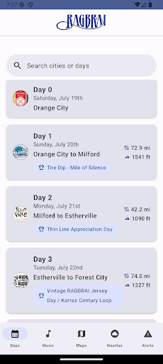
• Complete Route Coverage - 7 days, 412+ miles from Orange City to Guttenberg with detailed elevation profiles and timing
• Dual Route Options - Standard paved routes plus challenging gravel alternatives for adventure cyclists
• Interactive Maps - RideWithGPS integration, town vendor maps, and offline-capable navigation
• Live Entertainment Guide - Local bands and venues at every stop celebrating Iowa's small-town culture
• Weather & Safety Integration - Epic Ride Weather forecasts and Alert Iowa emergency notifications
ROUTE HIGHLIGHTS:
- Day 1: Orange City to Milford (72.9 mi, 1541 ft climb)
- Day 2: Milford to Estherville (42.2 mi, 1090 ft climb)
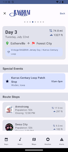
- Day 3: Estherville to Forest City (74.0 mi, 1327 ft climb)
- Day 4: Forest City to Iowa Falls (72.1 mi, 1530 ft climb)
- Day 5: Iowa Falls to Cedar Falls (51.9 mi, 1300 ft climb)
- Day 6: Cedar Falls to Oelwein (38.3 mi, 1143 ft climb)
- Day 7: Oelwein to Guttenberg (62.5 mi, 2429 ft climb)
Perfect for RAGBRAI riders, media, and cycling enthusiasts planning for the main event. Works offline in rural Iowa with optional connectivity for weather updates and push notifications.
Experience Iowa's cycling tradition with the official RAGBRAI app - where every mile tells a story.
Data safety
Safety starts with understanding how developers
collect and share your data. Data privacy and security practices may vary based
on your use, region, and age. The developer provided this information and may
update it over time.
Whats New
Minor bug fixes and improvements. Install or update to the newest version to check it out!