What I Take? It is an application that shows the routes of public transport in the metropolitan area of Tepic - Xalisco in Nayarit, Mexico, where you can perform various types of searches and learn their trajectories.
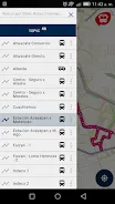
- Search sites:
Write the name of a site of interest (neighborhood, school, park, shopping center, etc.) and application filter that routes pass to a distance of 400 meters from there.
- Coordinate Search:
Using a click anywhere on the map within the city will know which routes pass within 400 meters from the point that you chose.
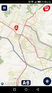
- Search A -> B
Only marks a point of origin and destination, and the application will show the routes that take you either from your location or any other point marques as origin to the destination point.
We organize to provide users of public transport in the city of Tepic, a reliable source query truck routes.
Once you wondered What I Take?
Data safety
Safety starts with understanding how developers
collect and share your data. Data privacy and security practices may vary based
on your use, region, and age. The developer provided this information and may
update it over time.